Tag Archives: Radio

PPL-ASEL Checkride

Last week I called my DPE as previously discussed and got a cross country from KLHM to KMRY for planning. Also, I got the weight and balance details which I worked out in advance. Otherwise, I was asked to prepare per the ACS.

I arrived at Lincoln last evening and stayed overnight. Lincoln airport charges a $5 transient parking fee for overnight tie down. You can pay at the self-service box on the ramp. You can get an Uber from the airport to one of the local hotels. I had tried calling the airport twice to find out the availability of courtesy cars but only reached their voicemail.

My checkride started this morning at 9am. I met the DPE at their hangar. DPE wanted to start off by understanding how I got into flying and what I expected to do with the license. Since I’m interested in volunteering, DPE suggested I go a step further and see if I could work with companies who need photographers/pilots (eg. Sierra Pacific, US Fish and Wildlife). A commercial license will be helpful in that case.

After a few minutes, we started by reviewing and signing my IACRA online, reviewing identification documents, knowledge test, pilot and medical certificates and the pilot logbook for all the necessary endorsements. Next, I was asked to show how the aircraft is ‘qualified’ for our flight today. I went through the annual for airframe, engine and propellor, reviewed the ADs that have been completed with our 50-hr inspections. We had a discussion around whether or not our planes need a 100-hr inspection considering our club is owner-operated. These planes are not considered ‘for-hire’ for flight training (because the instructors are paid directly and they are not employed by the club). DPE explained that especially for today’s checkride, since it is not flight training we don’t need a 100-hr inspection. We talked about always logging accidents and incidents with the NASA Aviation Safety Reporting System and the associated form at the back of FAR/AIM (on page 1127 in the 2018 edition).

The oral exam was a combination of scenario based and direct questions. DPE let me refer materials (I had all the handbooks and manuals on my iPad) whenever needed and occasionally even pointed out specific sections in documents to refer.

First scenario was that of a private pilot taking friends to Monterey who offer to pay for the trip. Upon landing at Monterey, FAA agent does a ramp check. We talked about this at length, including ADM, hazardous attitudes, PAVE checklist especially external pressures since friends are involved. We also discussed IMSAFE and personal minimums. It helped in the discussion that I had one already filled out. A variation on the scenario was that I had flight following but my radios died before entering Monterey class Charlie. What would I do next?

We looked at weight and balance for the aircraft. I was asked to explain how I know if it is still valid.

If placards have faded, is the aircraft still fit to fly?

We had a discussion around inoperative equipment. How do we know if fuel gauge isn’t working and would we fly with such a gauge? How about a failed attitude indicator? How should we deal with inop equipment? Then we went on to minimum equipment list, equipment list from the POH listing required equipment, A TOMATO FLAMES checklist.

Know the ADs for your aircraft, when they were complied with and in the case of recurring ADs the frequency at which to inspect.

Then we had a detailed discussion of the electrical system and fuel system. What if either the alternator or battery fails during flight. A related question was why the alternator generates 14V when the battery is only rated for 12V.

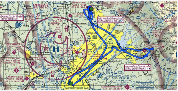
Next we reviewed the cross country plan and discussed the route, altitude choices, airspaces along the way, requirements for the airspaces, special use airspaces and their requirements, flying over water and class Bravo considerations. If the cross country was planned at night what I would do differently, do I need oxygen. Requirements for flying under class Charlie shelf and over class Delta. DPE liked the fact that I had the plan on Foreflight/iPad as well as a written cheat sheet with landmarks, headings and ETA.

We took a break before starting on the flight portion of the test. DPE said I can take all the time I needed to adequately set up for each maneuver. Flight following was at my discretion and if I chose then I should only ask for it until the maneuver area south of Sacramento.

Winds were really picking up outside so I could call for discontinuance if I was ever uncomfortable either before or during the checkride. DPE wanted to see one go-around during the course of the test. As expected, we’ll start the cross country but wouldn’t go beyond Sacramento and DPE wanted me to check the weather at all the local airports and point out the ones I wouldn’t be comfortable landing for a diversion. Mather and Auburn were at or above my 10 kts crosswind component limit and the rest were manageable.

We started with a soft field takeoff and I called up Norcal for flight following (just because I could) and started tracking heading for first checkpoint on the cross country plan to intercept a radial from SAC VOR. Then I turned towards the VOR for my second checkpoint when the DPE said passengers in the back seat were feeling airsick. So I changed destination to KSAC. We landed then taxied back for a soft field takeoff departing right 45 towards Folsom lake for maneuvers. First, I realized my window was open when I took off and tried to close it on upwind but the winds were blowing me around. Steve’s advice to “fly the plane” rang in my ears and I left the windows alone to stay with the climb out at 75-80 kts and stabilizing before trying again to close the window. Second, in the distraction I almost busted into Sacramento’s class Charlie. En route, I donned the hood for instrument work and two unusual attitudes.

Next we started with slow flight in the landing configuration. DPE asked me to start a shallow turn at 60 kts when I was still getting configured towards my usual flying slow flight at 50 kts. So I was a little bit caught off guard. We discussed this later in the debrief after checkride. Then I did power OFF stall in the landing configuration, power ON stall in the takeoff configuration, steep turns to the left then right. From there we proceeded to Lincoln for some landings.

First was a soft field landing, touch and go back for short field landing. Then we did a forward slip to landing. My approach was too high so went around and tried it again. KLHM was too busy so I was #3 and the aircraft in front of me was too slow so I did a left 360 and rejoined final for a full stop and the conclusion of checkride. I was allowed to use a combination of Garmin 430, VOR, Foreflight on iPad and scribbled notes for navigation. We taxied back to the hangars and the DPE congratulated me that I had passed the checkride as we were getting out of the aircraft.

Some feedback that I received after the checkride:

  1. My radio work was excellent both on towered and non-towered airports
  2. Recovery from unusual attitudes under the hood were very good and prompt
  3. DPE never felt that safety was a concern (even when I realized my window was open).
  4. Use one full arc nose-up trim on steep turns and a little bit of power as needed then the plane should fly the steep turn without elevator back pressure.
  5. Stay on the centerline with lots of right rudder especially on soft field takeoff when the nose wheel is off the runway. So there is even less directional control with sole reliance on the rudder which itself is inherently not very effective on the high angle of attack configuration.
  6. Don’t start working on instrument approaches until perfecting instrument scan and holding altitude/heading accurately.

We started at 9:10am and I was done by 2:30pm. Felt at ease throughout and never felt rushed. I had sufficient time to review my maneuver checklist before each one. I gave it my best shot and I’m sure I used the full latitude of ACS standards i.e., my performance  was by no means perfect. After all, what I’ve just earned is a Private Pilot’s License to learn.

Checkride Route

$100 Hamburger

A few of us at work decided a couple of weeks ago to plan a fly-in to Sacramento Executive airport (KSAC) and have lunch at the Aviator’s Restaurant in the airport terminal. Earlier in the week, some of us met to discuss routing and other considerations for the fly-in. I was the only student in the mix and the rest were planning to arrive from Tracy, Reid-Hillview, Palo Alto and San Carlos. This would qualify for cross-country time in the logbook since KSAC was 51nm from KLVK.

My route would take me over the east end of Los Vaqueros reservoir, then directly to the Sacramento VOR and turning right to the airport nearby. On the way at Walnut Grove are three tall guyed radio towers which are each over 2000′ tall and one of the tallest structures in the world. Just for comparison, the World Trade Center towers were only 1368′ and the Eiffel Tower is 1063′ tall.

I met my CFI at the airport terminal at 8:30am to get a cross-country endorsement in the logbook. Previously I had briefed via Foreflight on my iPad for the weather and NOTAMS. It was going to get windy in the central valley starting around 11am but the winds were forecast to die down late in the afternoon at KSAC. The winds might still be right around my crosswind maximum of 10kts at KLVK so I discussed with my CFI that I will not takeoff until late in the afternoon and keep an option open to divert to KCCR Concord Buchanan airport.

To beat the winds I took off early and was airborne at 10:15am. Livermore tower now can initiate flight following and I had a squawk code dialed in before takeoff. Runway 34 is closed until Feb 15 and the winds were 320@7 favoring runway 30 and I was parked next to the terminal at 11:04. It took longer than the estimated 36 minutes for two reasons – the headwinds were stiffer than the forecast 335@17 at 5500′ cruising altitude and I forgot to lean the mixture for maximum engine performance.

Food and ambiance were quite good at the restaurant – I ordered a “$10 Pasta”. The seating area overlooks the taxiway and runway 02/20. We had a 13 people show up in 6 planes – one was a Lake and the rest were Cessna 172.

As we were lunching, the winds began howling outside from 320@17-28. Around 3pm the first plane (C172) from our group took off and we could see the wings rocking side to side as the pilot maintained runway course against the stiff crosswind. The rest of us hung out for another 30 minutes and slowly dispersed. I remained at the terminal checking the weather at Concord, Tracy and Livermore. Tracy was another option because the winds were generally lined up with runway 30.

Around 5pm I texted my CFI about my intentions to fly to Concord since the winds were from 360 and runway 01 would have been fine. Livermore had started to look better and he asked me to monitor that as well. I finished pre-flight, fueled up and called up ASOS one more time at both Concord and Livermore. When I took off from KSAC winds were 310@21-27.

KLVK 110053Z 01008KT 10SM CLR 19/M08 A2991 RMK AO2 SLP126 T01891078

The crosswind at Livermore was within my limits so I headed direct with the option to divert to Concord if needed. Climb out of Sacramento was bumpy but once I reached 4500′ cruise altitude, it was smooth air with a healthy tailwind. My airspeed was around 105 and at one point my ground speed was 138kts! En route, I saw the sun set in the west and in 25 minutes I was over Las Vaqueros reservoir. As I began my descent the winds picked up once again over the Livermore hills and tower first reported winds 340@8-21 and then 320@5-21 when I was on short final. The cross winds were quite stiff requiring full left rudder and right aileron to stay aligned with the runway on a forward slip. The landing was challenging but I was able to stick the landing. I was glad to be back safely on the ground, parked at 6:09pm, just within the 30-minute window after sunset at 5:41pm that my CFI had set as the limit.

In retrospect if I had had to divert from Livermore to Concord, it would have been a night solo for which I wasn’t endorsed. Departing 30 minutes earlier from Sacramento or heading only for Concord would have been safer options.

VOR Morse Codes

The weather was beautiful this weekend and I had a chance to fly 906MD on both mornings. Among other things, I had a chance to practice VOR radial intercepts. Recently FAA has decommissioned the Manteca VOR but nearby Linden and Modesto are intact and functional.

The sectional chart shows the following snippets for the two VORs in the San Francisco airspace. The aircraft is equipped with Garmin 430 GPS and I tuned to them to show how the morse code identifier sounds. The morse code helps to confirm that the right station is tuned before relying on it for navigation.

First solo cross-country

I flew my first solo cross country to Merced (KMCE) and back. After left downwind departure and shortly after Livermore tower approved a frequency change, my first order of business was to establish contact with Norcal and request flight following. Per frequencies published, I tried 123.85 but no response. My instructor had mentioned that this frequency doesn’t work and to try 125.1 instead. But when Srinath flew last year, he had established contact with 123.85. Not only was there no response but there was no chatter on this frequency contrary to what I had expected from Norcal. Next I tuned into Oakland Center at 126.85 but again no chatter and neither was there a response to my request. I waited a while, was already climbing over the hills at 4000′ and was anxious to get in touch with Norcal. So I tuned back to Livermore tower and got the frequency as 125.1. Successfully established contact with Norcal on that frequency and got a squawk code for flight following. Why the charts do not list 125.1 is a mystery to me.


The course was to fly heading 84 (after wind correction at altitude) out of Livermore. That would have me skirting along the south end of restricted area R-2531 all the way to where I-5 meets I-580. At that point I turn to heading 121 to Gustine (3O1). I was doing 100kts airspeed with 128kts ground speed with a healthy tailwind at 5500′. My estimate was 110kts with an airspeed with 100 kts.

Along the way, I would pass Crows Landing airport when I cross radial 191 from Modesto VOR 114.6. Gustine is then along radial 328 from Panoche VOR 112.6.

After passing Gustine with the airport directly below me, I turned to a heading of 69 that would have put me straight into Merced. About 8 miles from the airport, I spotted the airport in the distance and set myself to enter on the 45 degrees for left downwind into runway 30. Winds were from 320@11kts, it was already warm at 27c and density altitude was 1600′ at the airport whose elevation was only 155′ MSL. It turned out that the airport I spotted was Castle (KMER) which is just a few miles to the north of Merced. I was growing suspicious because I didn’t see any traffic or aircraft at the airport and was beginning to wonder if it was even an airport at which point I realized it was not my destination.

Glancing at the GPS, I found Merced off to my right at which point I cross referenced with my notes that Merced was to the west of Hwy 99 whereas the airport I initially saw was on the east side of Hwy 99. The runway at Merced is 5914′ x 150′ which is plenty for a C172. The airport has a tower but it is no longer operational. I pulled into the transient parking area and reset my notes and instruments for the return trip.
Confusion at KMCE

On the way back from Merced, Norcal transferred me to 123.85. Not sure how the frequency is working now when I had trouble connecting on the way out of LVK. There was some aerobatic activity over Tracy about which the controller alerted me and requested I stay above 4200′. It was getting quite hot and turbulent over the Altamont pass. The controller at LVK was clearly overloaded with the traffic. He ignored my first call and asked me to stay outside Class D airspace on my second call before clearing me for landing on 25L. Another aircraft was asked to stay on downwind and it reported approaching Altamont when the controller turned them base!

The course I had planned had a 144nm (72nm distance each way). The actual course I flew was 164nm (85nm + 79nm).

Solo x-country KLVK-KMCE-KLVK

High and Low Air Work

I’m flying with Steve today on dual instruction. As we climbed out of Livermore, I noticed deteriorating visibility which I assumed was a cloud layer. Steve pointed out that it was actually smoke from a very large wildfire burning near Big Sur on the California coast. On the east side of the Livermore ridge the conditions were a little better, enough for us to continue with a training flight after having had thoughts along the way of possibly turning back.

At 3000′ the smoke layer wasn’t bad so I did steep turns on the right and left. Still not very comfortable doing steep turns. Steve demonstrated a turn which was fairly steep  and he might have pulled up to keep the nose from dropping and I was not comfortable with the associated sensations.

Next we did slow flight and then a few different stalls – power off stall in the landing configuration, power-off stall on a right turn and then a power-on stall.

We went through a routine engine out simulation and at the end of it we spotted the pipeline and transitioned into S-turns. At that time I spotted another aircraft which was also flying at our low altitude seemingly also using the pipeline for making S-turns. We watched it for a while as it appeared they were leaving the area but then they really didn’t. After one turn we decided to leave the area and do turns about a point at a nearby location.

Lots of traffic everywhere today. As we were approaching Byron and announced our position over Discovery Bay, another aircraft was taking off and was going to do a 270 en route to Livermore. That would put it coming straight at us at comparable altitude. Radio communications helped save the day with each other knowing our locations.

There were gliders flying today at Byron and there was unexpected thermals as we approached the threshold for Rwy 30 that caused me to stay up longer even though I had pulled out the power on the engine. Two touch and go and we headed back to Livermore.

Solo stalls

Today I set out to practice solo stalls for the first time. I had 737GM reserved and it was mostly a smooth ride as I flew over Byron airport at 2500′ heading to the practice area. At 3000′ I started practicing slow flight and making shallow turns at slow flight. But first, by making clearing turns.

After slow flight, in the landing configuration I tried a stall first and then dropped the nose before the stall was achieved. Tried it again and this time the stall was achieved with quick recovery. Very quickly I decided that was enough and proceed for a couple of touch and go’s at Tracy airport before heading back to Livermore. By the time I returned, winds had shifted and I landed on 7L as tower switched the traffic around to make up for a northeasterly wind.

Local patterns

Srinath and I both flew patterns today at Livermore, one after the other. N906MD continues to have starting trouble.

The traffic controller lost situational awareness on more than one occasion – when I was taxiing off 25L back for takeoff and again when there were a few planes in the air. On the latter situation, he sent one of the planes on downwind and never called his base turn until the pilot radioed and said he had gone almost to Brushy Peak. He then asked for my position and turned me base in front of the other plane.

When Srinath took off, he was cleared for 25R but for a left pattern on 25L. The radio communication snippet will be helpful because it was confusing to me the first time I heard it.

During my pattern, I asked to be switched to 25R when I was cleared for left pattern on 25L. The controller accommodated me and that too is a helpful radio communication snippet.

Solo in the Tri-Valley

Starting up 737GM was a bit of a bear but chose to fly it this morning because 906MD’s carburetor was being re-worked due to starting problems. Tower cleared me for takeoff on 7L. Winds 130@5kts but quite variable.

Flight to Byron was quite straightforward and it was a good smooth landing. On the flight from Byron to Tracy, I had still been tuned to the Byron radio and I was wondering why Tracy traffic wasn’t announcing on the radio. I was still hearing Byron traffic. While in the pattern at Tracy, I saw an aircraft taking off and one waiting to take off and I had not heard either of them speak on the radio. It was only when I was nearing base turn in the Tracy pattern that I realized my mistake. Landing at Tracy was also good. I next proceeded to New Jerusalem where it was a bouncy touch and go. The flight back to Livermore was uneventful.

apr-16-track-log


Dual Cross Country to Salinas

It is Srinath’s turn to fly cross country to Salinas (KSNS) and back. It was an exercise in using the VOR and sectional chart to identify landmarks along the way for navigation. En route as we flew to the west of the mountain ranges, downdraft from the winds over the hills caused us to descend even though we were powering our way through. Lick Observatory on Mt.Hamilton was a sight to see along our course. There was an aerobatic Extra 300 practicing along our course and we hoped and prayed the pilot was aware of our presence.

The return flight was bumpy all the way due to the winds streaming over the mountain range. You can find the track log here.

Radio communications for VFR

The FAR/AIM chapter 4, section 2 defines the general framework for radio communications. Starting with the facility being called, then your full aircraft identification, state your position when operating on an airport surface, type of message to follow or your request itself if it is short. Here are some examples that I’ve encountered so far.

Just before starting to taxi out of the hangar after receiving a weather briefing (Yankee)

Livermore ground, Cessna 2 5 Echo Sierra Northeast Hangars taxi for takeoff with Yankee

Ground responds

Cessna 2 5 Echo Sierra Livermore ground runway 2 5 right taxi via Bravo

Pilot’s acknowledgement

2 5 right via Bravo 5 Echo Sierra

After getting to the run-up area and completing the pre-takeoff checklist

Livermore tower Cessna 2 5 Echo Sierra 2 5 right ready to go right downwind

Tower responds

Cessna 2 5 Echo Sierra Livermore tower number 2 for departure hold short of runway 2 5 right

Pilot acknowledges

Hold short 2 5 right 5 Echo Sierra

Tower asks to wait

Cessna 5 Echo Sierra runway 2 5 right, lineup and wait, traffic in the pattern

Tower gives clearance for takeoff

Cessna 5 Echo Sierra, the upwind traffic is in the right pattern, right downwind approved runway 2 5 right, cleared for takeoff

Pilot’s acknowledgement

Cleared for takeoff 2 5 right, 5 Echo Sierra

Approaching Byron for a landing. It is a non-towered airport.

Byron area traffic, Cessna 2 5 Echo Sierra is over Discovery Bay, inbound for right traffic runway 3 0, Byron

Approaching Byron airport for a landing. It is a non-towered airport.

Byron area traffic, Cessna 2 5 Echo Sierra is on the 45, inbound for right traffic runway 3 0, Byron

At Byron airport, getting ready for a takeoff followed by a landing. It is a non-towered airport.

Byron area traffic, Cessna 2 5 Echo Sierra is taking runway 3 0 for right closed traffic

Ready for a takeoff from Byron, heading to Livermore and on the way flying midfield over the runway. It is a non-towered airport.

Byron traffic, Cessna 2 5 Echo Sierra is taking runway 3 0 for an overhead 2 7 to Livermore

Flying over midfield over Byron airport. It is a non-towered airport.

Byron area traffic, Cessna 2 5 Echo Sierra is crossing midfield at 1200

Approaching New Jerusalem airport to check the runway, traffic pattern and wind direction. It is a non-towered airport with nobody around at the moment.

New Jerusalem traffic, Cessna 2 5 Echo Sierra is about 3 miles to the northwest inbound for an overflight for wind check

After circling the runway in a left traffic pattern, we announce our location.

Cessna 2 5 Echo Sierra is left crosswind to runway 3 0 New J