A question was posed in a pilots group: Why is “SFO R-101” radial charted as a thin line within the localizer course depiction in the plan view section of the KSFO ILS or LOC RWY 28R approach chart?
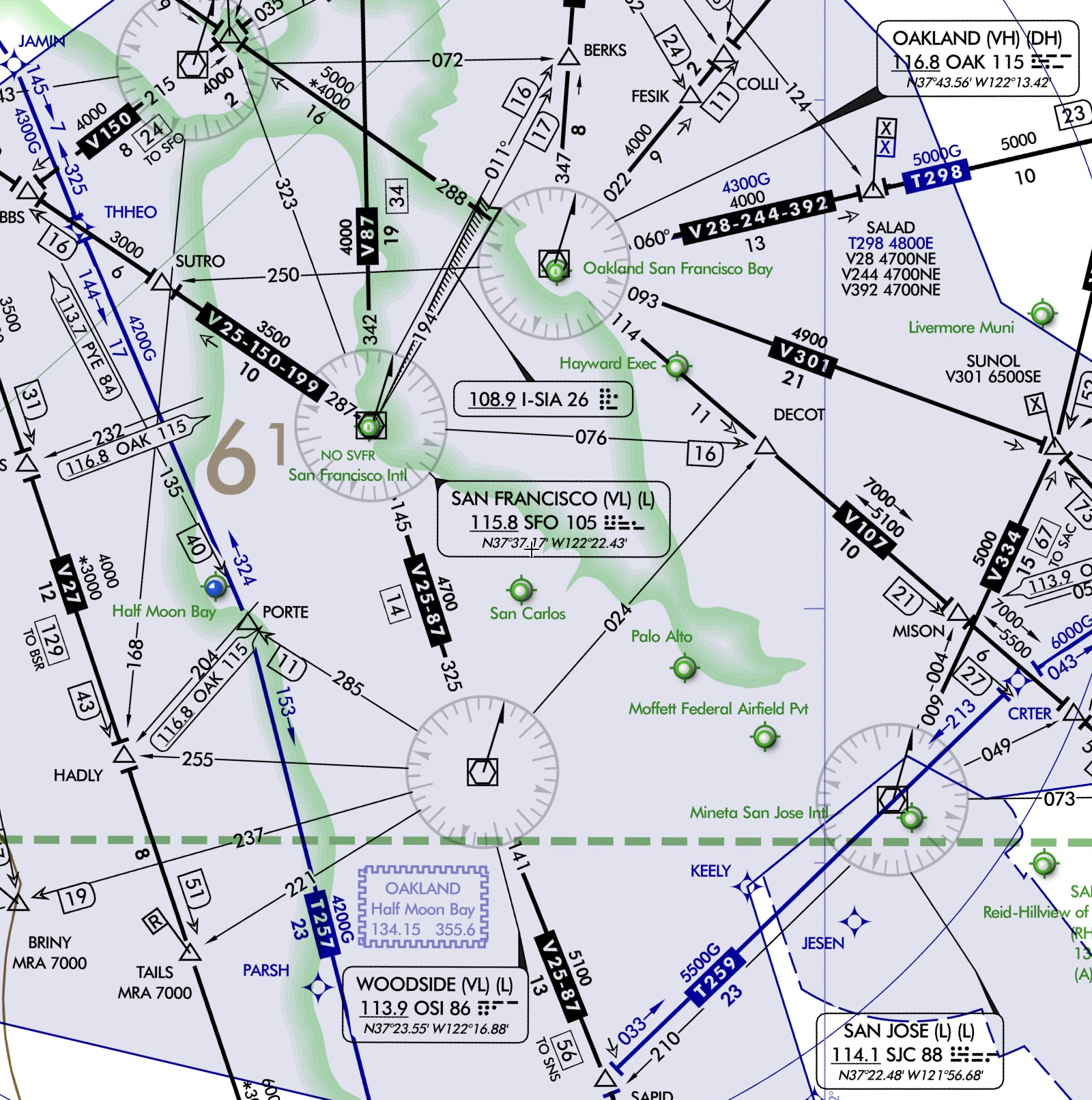
Let’s back up and imagine your aircraft, N1234A is equipped with VOR receiver only and with no DME or GPS equipment. There are no notes on the chart that requires DME or GPS so it should be possible for N1234A to fly this approach. The IAFs for this approach are DUMBA INT, EDDYY and ARCHI. However EDDYY and ARCHI are GPS waypoints which N1234A cannot identify. So DUMBA INT is the only viable IAF. Looking at the Low IFR chart, DUMBA is not located on any airway and there are no feeder routes charted from the enroute environment. So how does one transition from the enroute environment and navigate to the IAF?
ATC must step in not only to provide a transition route for the pilot between the enroute environment and the IAF but also to provide a safe altitude on this route. Appropriately, the note published on this chart confirms that either “RNAV 1-GPS or RADAR required for procedure entry.” FAA Order 8260.19K section 8-6-10(g) reads as follows:
Where use of Radar is the only acceptable method for procedure entry from the en route environment, enter EQUIPMENT REQUIREMENTS NOTE: RADAR REQUIRED FOR PROCEDURE ENTRY.” See paragraph 8-6-9, for additional equipment that may be used in addition to, or in-lieu-of Radar.
“RNAV 1-GPS” refers to the lateral navigation accuracy of 1 nm, expected to be achieved at least 95 percent of the flight time [AIM 1-2-1 (b)(2)(e)]. For comparison, your instrument approach certified RNP 0.3 GPS is more than three times as accurate.
When ATC radar vectors N1234A to DUMBA, how do you know when you have arrived at the IAF? ATC has limited ability to help you know that you have arrived at the fix (or any of the subsequent fixes on the approach for that matter), otherwise the word RADAR would be listed at each fix on the profile and plan views. So you are on your own to locate your position and descend to the appropriate altitudes if you are on the LOC approach. Looking at the chart, it appears the outbound localizer course 104°, Woodside VOR (OSI) R-036, Oakland VOR (OAK) R-138 and San Francisco VOR (SFO) R-101 all converge at the IAF. But, what is the necessity for so many radials to be charted? Section 7-5-2(a)(5) of FAA Order 8260.19K reads as follows (emphasis in boldface is mine):
Transitions must not be established from outside of the normal clearance and buffer areas unless they have been flight inspected and the minimum localizer clearance requirements are met. Where such a flight inspection is unsuccessful, an intersection must be established on the localizer course, or a lead-radial established within localizer coverage. When established on the localizer course, the transition route from a VOR or non-directional radio beacon (NDB) must be predicated on a NAVAID or fix which does not utilize the localizer (i.e., the fix must stand alone on a localizer course for definition) [see paragraph 8-5-2.g(3) and figure 7-5-4].
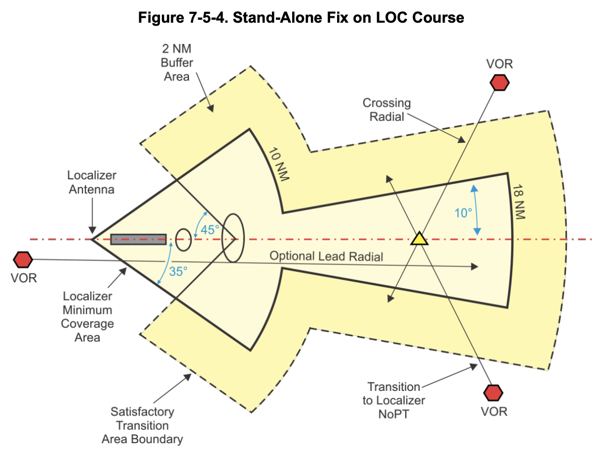
Comparing this diagram with the approach plate, it appears that DUMBA INT must be identified using any 2 cross radials from OSI, OAK and SFO. As one is vectored from OSI or OAK, depending upon their enroute arrival, they can join the published radial from SFO to get established on the inbound approach course and use the OSI or OAK radial intersections to identify DUMBA.
DUMBA intersection is 16.1nm from the localizer. At that distance, theoretically the localizer signal coverage area spans up to 10° on either side of the localizer course. This translates to a signal range spanning up to 2.8nm on either side of the course. In reality, the signal range may be degraded due to a variety of reasons so it is routinely flight checked by the FAA. Adjustments to the approach are made over time to compensate for any deficiencies in the signal range.
Coming from OSI to establish on the localizer inbound requires a 110° left turn and coming from OAK to establisher inbound requires an even greater 146° right turn. In reality, the degree of turn depends upon the “Approach Gate” to which the airplane is being vectored. If the degree of turn is too steep, then waiting to turn inbound until arriving at the IAF may mean that N1234A will overshoot the localizer signal coverage area – traffic flying into KSFO are typically very fast moving. Within Class B airspace, aircraft can fly at up to 250 kts which translates to a standard rate turn radius of 1.6nm. Conversely, if the aircraft wishes to turn early in anticipation of establishing inbound on the approach, then the turn must be commenced prior to reaching the localizer signal area. In either case, SFO VOR guidance is required to get (re)established on the localizer.
FAA Order 8260.3G (TERPS) section 2-4-3(a)(1) states:
When the angle between an initial approach course and intermediate course exceeds 90 degrees, a radial or bearing which provides at least 2 NM of lead must be identified to assist in leading the turn onto the intermediate course…
Even though SFO R-101 not a “lead radial” since it is not marked as LR-101, the spirit of this section may apply here. VOR signal is omnidirectional and has a 40nm service volume even at 1000′ ATH (above transmitter height). VORs, and not Localizers, are used for navigation in the enroute and terminal environments. Charting SFO R-101 at DUMBA INT helps guide aircraft towards the final approach course. Once we are guided by the VOR into the localizer coverage area i.e., when the localizer “needle comes alive”, N1234A can flip frequencies to the localizer and get established inbound for the approach. [Alternately, if ATC is continuously vectoring N1234A until joining the final approach course, then R-101 is unnecessary.]
These days aircraft flying into KSFO are very likely RNAV (GPS) equipped. So it would be interesting to know how often this approach is actually being flown using only RADAR guidance. Perhaps it is charted only as a contingency option if/when GPS signals are disrupted in the area.


